-
МјРЇСІИёСЖШИМі
-
 И№ОЫ КИОЫ Йъ ЗЛЦЎЧЯБт~ ИЎСЖЦЎ ПЙОрБюСі
 89,620
 -
 [ЧЪИЎЧЩ ММКЮ] ФЋИ№ХзНК ПЉЧр 100Йш СёБтБт
 49,821
 -
 ИЖДвЖѓ НУГЛ - ИЎРп АјПјСЄКИ. (ЛчСј 16Рх ЦїЧд)
 30,851
 -
 ММКЮРЧ СіПЊСЄКИ15,564
 -
 ИЖДвЖѓ БйБГ - ЕћАЁРЬЕћРЬ ПЉЧр СЄКИ14,408
 -
 [ЧЪИЎЧЩ ММКЮ/ИЗХК] ШЃХк МїЙк ПфБн Йз СЄКИ13,363
 -
 КИЖѓФЋРЬРЧ И№Еч И№НРРЛ КММі РжДТ ЛчСјУИ.13,176
 -
 ИЖДвЖѓ БйБГ - ЦХЛѓЧб ЦјЦї ПЉЧрСЄКИ12,875
 -
 [ММКЮ-ЙшМБТјРх] МБЙкШИЛч РќШЙјШЃПЁПф~12,500
 -
 ИЖДвЖѓ СіПЊ(ПЁИЃЙЬХИ -ИЛЖѓХз)РЧ СіЕЕ/ЧбБЙ РННФСЁ/МюЧЮИє12,151


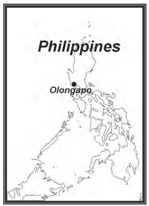
The City of Olongapo (Tagalog: Lungsod ng Olongapo; Sambal: Syodad nin Olongapo) is an independent
highly urbanized city located in the province of Zambales, Philippines. According to the latest census, it has
a population of 227,270 people in 50,300 households.[3] Along with the town of Subic, it comprises the Metro
Olongapo, one of the twelve Metropolitan Areas in the Philippines.
Etymology
According to popular legend, there once was a group of warring tribes who lived in the area in and around what
is now the modern city. A wise old man, seeing the perils of disunity, exerted great effort toward uniting the
warring tribes. There were, however, some who bitterly opposed his idea, and one day the old man just
disappeared.
After a long search, the old man's body was found, but with the head missing. It is said that the tribesmen
launched search parties to locate the severed head of the man. (To the Sambal, decapitation was the only
permissible form of assassination.[5])
These efforts proved to be futile, and the search was eventually called off. A boy, however, vowed to himself that he would not stop searching until he found the elderтs head. He searched for weeks, but found nothing. Then, one day, he chanced upon what appeared to be the old manтs head, resting on top of a bamboo pole. The boy ran back to his people crying, тOlo nin apo! Olo nin apo!т (тhead of the elderт in Sambal; translates as тulo ng apoт[6] in Tagalog), running hysterically from village to village. The phrase stuck, and that, according to legend, is how the area got its name, Olongapo.
To this day, the old manтs head acts as a symbol of the unity of the people of what is now a modern city History
Spanish Period
On March 8, 1885, the Spanish Naval commission authorized construction of the Arsenal at Olongapo. The
Spanish planned to make their naval station and the village of Olongapo an island, protected against attack
by insurrectos. The Spanish Navy Yard occupied the entire area east of the Spanish Gate. Employing Filipino
labor, they did extensive dredging of the harbor and the inner basin and built a drainage canal. The canal served both to drain the swampy area around the yard and also to form a line of defense.
Within ten years, the Spaniards had erected walls and markers to fence off the arsenal. They had shops and buildings erected. The Spanish government spent almost three decades developing the Naval Station.
Geography
Location
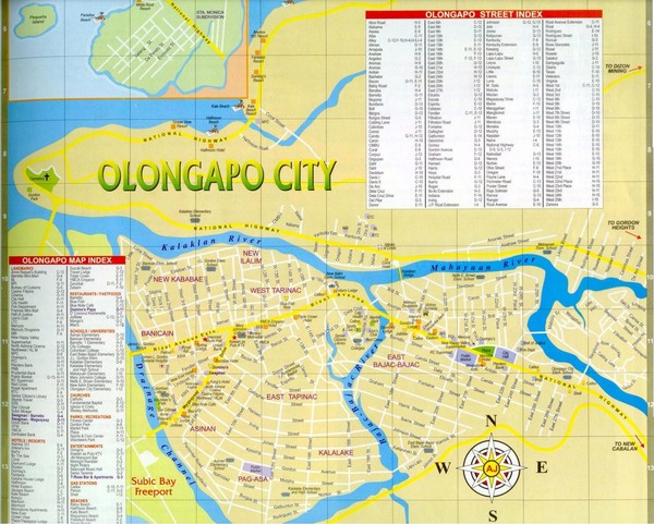
Situated at the Southern entry point of Zambales and the Northwestern interior of the Subic Bay area, Olongapo
City is approximately 127 kilometres (79 mi) north of Manila.
The city proper is located on a 6.48 km2. Tidal flatland, and the city is characterized by rugged and mountainous terrain. The land area of Olongapo City is 185 square kilometers or 18,500 hectares.
Because of its peculiar geographic location - the Zambales mountains on its three sides, Bataan and Subic
Bay at its base - development of city land is limited. Also, the territorial borders from nearby towns are not
properly marked.
Coordinates
Geographical coordinates in decimal degrees (WGS84)
Latitude : 14.829
Longitude : 120.283
Geographical coordinates in degrees minutes seconds (WGS84)
Latitude : 14 49' 45
Longitude : 120 16' 58
Climate
From late October through February, the weather in tropical Olongapo is relatively cool. Temperatures increase
slightly from March to May, which are the warmest months of the year in this part of the Philippines.
The rainy season begins in June and continues through October. At times rains are heavy and flooding can
occur.
The city receives an average of 3,590 mm rainfall every year. Temperatures range from an average of around 25ТАC degrees in November to around 28ТАC in May.
- ЁЄ
- ЁЄ
- ЁЄ
- ЁЄ
- ЁЄryWvMVxeet
- ЁЄryWvMVxeet
- ЁЄryWvMVxeet\'\"\\(
- ЁЄryWvMVxeetщ\'\"\\(
- ЁЄryWvMVxeet
- ЁЄryWvMVxeet
- ЁЄryWvMVxeet
- ЁЄryWvMVxeet
- ЁЄryWvMVxeet
- ЁЄryWvMVxeet
- ЁЄryWvMVxeet


 ЧЪРкДхФФ ОпАЃЛѓДу ПРЧТ
 13ГтПЌМг МвКёРкИИСЗ 1РЇ

 ГЛАд ИТДТ ОюЧаПј УЃБт
 ИЎОѓ ЧаБГ ЙцЙЎБт
 СжИЛПЁ ГЛАЁ ОЕ КёПыРК?
 УжАэАЁМККё РЬКЅЦЎ СёБтБт
 ЧіСіПЁМЕЕ ЧЪРкДхФФ!
 ЧіСіПЁМ АЁДЩЧб


 ЧЪРк ЦЏБо Ч§ХУ! ФСНУОюСі МКёНК


