
-
МјРЇСІИёСЖШИМі
-
 И№ОЫ КИОЫ Йъ ЗЛЦЎЧЯБт~ ИЎСЖЦЎ ПЙОрБюСі
 89,457
 -
 [ЧЪИЎЧЩ ММКЮ] ФЋИ№ХзНК ПЉЧр 100Йш СёБтБт
 48,892
 -
 ИЖДвЖѓ НУГЛ - ИЎРп АјПјСЄКИ. (ЛчСј 16Рх ЦїЧд)
 30,789
 -
 ММКЮРЧ СіПЊСЄКИ15,529
 -
 ИЖДвЖѓ БйБГ - ЕћАЁРЬЕћРЬ ПЉЧр СЄКИ14,341
 -
 [ЧЪИЎЧЩ ММКЮ/ИЗХК] ШЃХк МїЙк ПфБн Йз СЄКИ13,319
 -
 КИЖѓФЋРЬРЧ И№Еч И№НРРЛ КММі РжДТ ЛчСјУИ.13,132
 -
 ИЖДвЖѓ БйБГ - ЦХЛѓЧб ЦјЦї ПЉЧрСЄКИ12,831
 -
 [ММКЮ-ЙшМБТјРх] МБЙкШИЛч РќШЙјШЃПЁПф~12,445
 -
 ИЖДвЖѓ СіПЊ(ПЁИЃЙЬХИ -ИЛЖѓХз)РЧ СіЕЕ/ЧбБЙ РННФСЁ/МюЧЮИє12,112
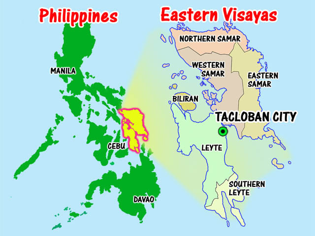
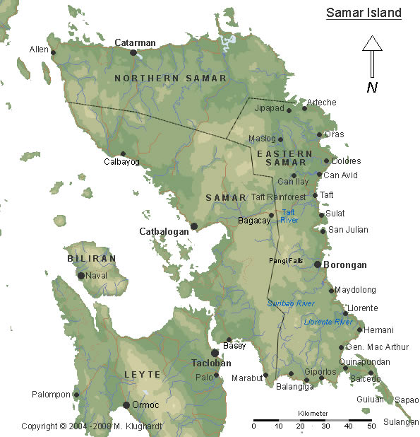
Samar Map
Western Samar, formerly Samar, is a province in the Philippines located in the Eastern Visayas region. Its
capital is Catbalogan City and covers the western portion of Samar island as well as several islands in the
Samar Sea located to the west of the mainland. Catbalogan City and Calbayog City, two of the three cities of
Samar Island, are located in the province of Samar. Bordering the province to the north is Northern Samar and
to the east is Eastern Samar. Samar is connected to Leyte via the San Juanico Bridge, which spans the San
Juanico Strait, the narrowest strait in the country. To the south of the province is the Leyte Gulf.
The province of Samar is a member of the Samar-Leyte (Waray Group), the sixth largest cultural-linguistic
group in the country. The majority (90.2%) of the total household population speaks the Waray dialect. The
remaining 9.8 percent speaks Cebuano (8.1%), Boholano (0.07%), Tagalog (0.5%) and other dialects. Other
languages used are English and Chinese.
Samar province has her share of natureтs bounty. Among the natureтs jewels which enchantingly lure tourists
and local folks includes unexplored mountains and caves which are inhabited by exotic wildlife, pristine shores
rimmed by unspoiled coral reefs, cloud-hidden lakes of blue surrounded by multi-colored flowers and beautiful
beaches and waterfalls nestled beside a mountain.
- ЁЄ
- ЁЄ
- ЁЄ
- ЁЄryWvMVxeet
- ЁЄryWvMVxeet
- ЁЄryWvMVxeet\'\"\\(
- ЁЄryWvMVxeetщ\'\"\\(
- ЁЄryWvMVxeet
- ЁЄryWvMVxeet
- ЁЄryWvMVxeet
- ЁЄryWvMVxeet
- ЁЄryWvMVxeet
- ЁЄryWvMVxeet
- ЁЄryWvMVxeet
- ЁЄryWvMVxeet


 ЧЪРкДхФФ ОпАЃЛѓДу ПРЧТ
 12ГтПЌМг МвКёРкИИСЗ 1РЇ
 ГЛАд ИТДТ ОюЧаПј УЃБт
 ИЎОѓ ЧаБГ ЙцЙЎБт
 СжИЛПЁ ГЛАЁ ОЕ КёПыРК?
 УжАэАЁМККё РЬКЅЦЎ СёБтБт
 ЧіСіПЁМЕЕ ЧЪРкДхФФ!
 ЧіСіПЁМ АЁДЩЧб


 ЧЪРк ЦЏБо Ч§ХУ! ФСНУОюСі МКёНК


