-
МјРЇСІИёСЖШИМі
-
 И№ОЫ КИОЫ Йъ ЗЛЦЎЧЯБт~ ИЎСЖЦЎ ПЙОрБюСі
 89,617
 -
 [ЧЪИЎЧЩ ММКЮ] ФЋИ№ХзНК ПЉЧр 100Йш СёБтБт
 49,810
 -
 ИЖДвЖѓ НУГЛ - ИЎРп АјПјСЄКИ. (ЛчСј 16Рх ЦїЧд)
 30,851
 -
 ММКЮРЧ СіПЊСЄКИ15,564
 -
 ИЖДвЖѓ БйБГ - ЕћАЁРЬЕћРЬ ПЉЧр СЄКИ14,408
 -
 [ЧЪИЎЧЩ ММКЮ/ИЗХК] ШЃХк МїЙк ПфБн Йз СЄКИ13,363
 -
 КИЖѓФЋРЬРЧ И№Еч И№НРРЛ КММі РжДТ ЛчСјУИ.13,173
 -
 ИЖДвЖѓ БйБГ - ЦХЛѓЧб ЦјЦї ПЉЧрСЄКИ12,873
 -
 [ММКЮ-ЙшМБТјРх] МБЙкШИЛч РќШЙјШЃПЁПф~12,500
 -
 ИЖДвЖѓ СіПЊ(ПЁИЃЙЬХИ -ИЛЖѓХз)РЧ СіЕЕ/ЧбБЙ РННФСЁ/МюЧЮИє12,151
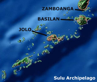
Jolo is a volcanicisland in the southwest Philippines. It is located in the Sulu Archipelago, between Borneo and Mindanao, and has a population of approximately 300,000 people.
Jolo is also the name of the town on the island which serves as the capital of the province of Sulu, within the Autonomous Region in Muslim Mindanao. About a third of the island's population live in the municipality of Jolo.
The island is part of the Jolo Group of volcanoes, and contains numerous volcanic cones and craters, including the active Bud Dajo cinder cone.
History
The Spaniards were never secure in Jolo so by 1878 they had fortified Jolo with a perimeter wall and tower gates, built inner forts called Puerta Blockaus, Puerta España, and Puerta Alfonso XII; and two outer fortifications named Princesa de Asturias and Torre de la Reina. Troops, including a cavalry with its own lieutenant commander, were garrisoned within the protective confine of the walls. From Jolo, in 1880 Col. Rafael Gonzales de Rivera who was appointed the governor dispatched the 6th Regiment to Siasi and Bongao islands. The Spaniards were not secure in their stronghold because it would be sporadically attacked. On 22 July 1883, it is reported that three unnamed juramentado succeeded in penetrating the Jolo town plaza and killed three Spaniards.; The word тAjuramentadoт was coined by Spanish colonel Juan Arolas after witnessing several such acts while serving duty in Jolo garrison.
The Americans arrived in 1899, and by the turn of the century, the Philippine-American War was raging in Luzon. So as not to spread out their forces, the Americans employed the classic divide-and-rule tactic. Maj. Gen. E.S. Otis, commander-in-chief of the US Forces, sent Gen. Bates to negotiate with the Sultan of Sulu. Known as the Bates treaty, the agreement provided for the exercise of American authority over the Sulu archipelago in exchange for the recognition of Muslim culture and religion.
Geography
The town of Jolo is located on the northwest side of the Jolo Island, which is located southwest of the tip of Zamboanga Peninsula on Mindanao island. The island is situated between the provinces of Basilan and Tawi-Tawi, bounded by Sulu Sea to the north and Celebes Sea to the south.
Jolo is a volcanic island, which lies at the center of the Sulu Archipelago covering 890 square kilometres (340 sq mi). The Sulu Archipelago is an island chain in the Southwest Philippines between Mindanao and Borneo, which is made up of 900 islands of volcanic and coral origin covering an area of 2,688 square kilometres (1,038 sq mi). There are numerous volcanoes and craters around Jolo with the last known activity (an earthquake assumed resulting from a submarine eruption from an undetermined location) taking place on September 21, 1897 causing devastating tsunamis in the archipelago and western Mindanao.
ETYMOLOGY
It is said that the Chinese traders who frequented the place, named Jolo after ho lâng (хЅНфКК). Ho lâng meaning тGood Peopleт reflects the Chinese perception of the natives. Chinese traders would leave goods on Joloтs shore, and find them undisturbed on their return. The phrase was eventually extended to ho ló (хЅН佬) meaning тGood Community.
TRADING CENTER
Jolo was the regional entrepot and developing city years before the Philippines was even a country. The Sulu economy formed its base around commerce and through the network of nearby trading partners. The Sultanate benefited from importing rice from northern Philippines, as the Sulu region had a chronic rice shortage. The Sultanate was unable to bring agriculture to its full potential because the area was prone to erratic rainfall and drought.
Language and dialects
Majority of Joloanos speak the native Tausug. English and Tagalog (Filipino) are also used specially in school and different offices within the town. Hokkien is also used by Chinese traders. Other languages include Samal/Badjao.
According to the 2000 Philippine census by the National Statistics Office, the Tausug language ranks number 14 with 1,022,000 speakers all over the country, the speakers mainly coming from Western Mindanao.
INDUSTRY
In Jolo, most of the residents are in the agriculture industry. Agricultural products include coconut, cassava, abaca, coffee, lanzones, jackfruit, durian, mangosteen and marang. Jolo is the only municipality in Sulu that does not farm seaweed. Fishing is the most important industry; otherwise people engage in the industries of boat building, mat weaving, coffee processing, and fruit preservation.
Political and societal significance
The Moros are geographically concentrated in the Southwest of the Philippines. Moros identify mostly with the majority Muslim nations of Indonesia and Malaysia because of their geographic proximity, and linguistic and cultural similarities. Moros have faced encroachments from the Spanish, Americans and now face the national Philippine government. Thus, the struggle for the Moro independent state has existed for over 400 years.
Currently, the Moro National Liberation Front is the Ruling Party of the Autonomous Region of Muslim Mindanao (ARMM). In 1996, the MNLF was granted leadership of the ARMM in response to the calls for Muslim autonomy. Abdusakur Tan is the governor of Sulu and Husin Amin is the mayor of Jolo. Politicians in these regions rose to power with the help of clan connections.
- ЁЄ
- ЁЄ
- ЁЄ
- ЁЄ
- ЁЄryWvMVxeet
- ЁЄryWvMVxeet
- ЁЄryWvMVxeet\'\"\\(
- ЁЄryWvMVxeetщ\'\"\\(
- ЁЄryWvMVxeet
- ЁЄryWvMVxeet
- ЁЄryWvMVxeet
- ЁЄryWvMVxeet
- ЁЄryWvMVxeet
- ЁЄryWvMVxeet
- ЁЄryWvMVxeet


 ЧЪРкДхФФ ОпАЃЛѓДу ПРЧТ
 13ГтПЌМг МвКёРкИИСЗ 1РЇ

 ГЛАд ИТДТ ОюЧаПј УЃБт
 ИЎОѓ ЧаБГ ЙцЙЎБт
 СжИЛПЁ ГЛАЁ ОЕ КёПыРК?
 УжАэАЁМККё РЬКЅЦЎ СёБтБт
 ЧіСіПЁМЕЕ ЧЪРкДхФФ!
 ЧіСіПЁМ АЁДЩЧб


 ЧЪРк ЦЏБо Ч§ХУ! ФСНУОюСі МКёНК


