


![]()


ЧЪРкДКНК

- ЁЄ ЧЪИЎЧЩ HOT
- ЁЄ ЧбБЙ HOT
- ЁЄ ЧСЗЮИ№МЧ HOT
- ЁЄ ШИЛчМвАГ
 13ГтПЌМг МвКёРкИИСЗ 1РЇ
ЧЪИЎЧЩПЌМіСЄКИ
ЧЪИЎЧЩЧаПјСЄКИ
ЧЪИЎЧЩПЌМіКёПы
ЧЪИЎЧЩУтБЙСиКё
ЧЪИЎЧЩСЄКИ
ЧиПмПЌАшПЌМі
СжДЯОюЧЪИЎЧЩ ПЌМі
ЧЪРкДТУрСІДй
ЧЪИЎЧЩ ЧіСі ЛчЙЋНЧ
ЧЪИЎЧЩПЌМіЧСИЎЙЬОі МКёНК
ЧЪИЎЧЩ ОюЧаПЌМіРЬКЅЦЎ
ЧЪИЎЧЩАЁСЗПЌМі
ЧЪИЎЧЩСЖБтРЏЧа
ЧЪРкДхФФЧиПмЛчЙЋНЧ
 ЧЪРкДхФФ ОпАЃЛѓДу ПРЧТ
 ГЛАд ИТДТ ОюЧаПј УЃБт
 ИЎОѓ ЧаБГ ЙцЙЎБт
 СжИЛПЁ ГЛАЁ ОЕ КёПыРК?
 УжАэАЁМККё РЬКЅЦЎ СёБтБт
 ЧіСіПЁМЕЕ ЧЪРкДхФФ!
 ЧіСіПЁМ АЁДЩЧб


 ЧЪРк ЦЏБо Ч§ХУ! ФСНУОюСі МКёНК


-
МјРЇСІИёСЖШИМі
-
 И№ОЫ КИОЫ Йъ ЗЛЦЎЧЯБт~ ИЎСЖЦЎ ПЙОрБюСі
 89,617
 -
 [ЧЪИЎЧЩ ММКЮ] ФЋИ№ХзНК ПЉЧр 100Йш СёБтБт 49,810
 -
 ИЖДвЖѓ НУГЛ - ИЎРп АјПјСЄКИ. (ЛчСј 16Рх ЦїЧд) 30,851
 -
 ММКЮРЧ СіПЊСЄКИ15,564
 -
 ИЖДвЖѓ БйБГ - ЕћАЁРЬЕћРЬ ПЉЧр СЄКИ14,408
 -
 [ЧЪИЎЧЩ ММКЮ/ИЗХК] ШЃХк МїЙк ПфБн Йз СЄКИ13,363
 -
 КИЖѓФЋРЬРЧ И№Еч И№НРРЛ КММі РжДТ ЛчСјУИ.13,173
 -
 ИЖДвЖѓ БйБГ - ЦХЛѓЧб ЦјЦї ПЉЧрСЄКИ12,873
 -
 [ММКЮ-ЙшМБТјРх] МБЙкШИЛч РќШЙјШЃПЁПф~12,500
 -
 ИЖДвЖѓ СіПЊ(ПЁИЃЙЬХИ -ИЛЖѓХз)РЧ СіЕЕ/ЧбБЙ РННФСЁ/МюЧЮИє12,151


- РЬИЇ : tutors
- РлМКРЯ : 2013-05-09
- СЖШИМі : 3935
- УпУЕМі : 0

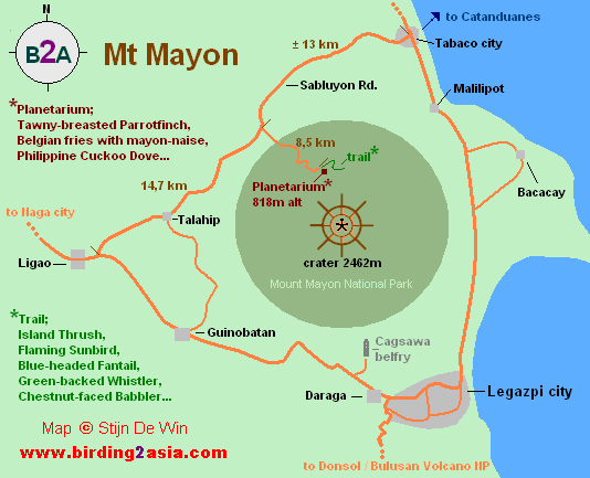
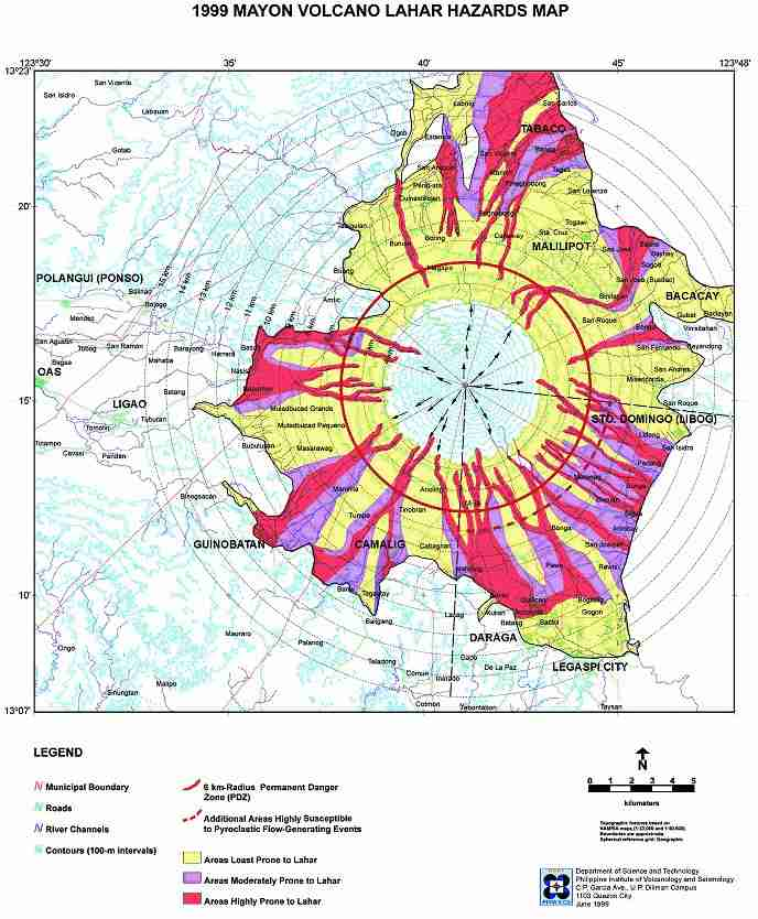
Welcome to the Mayon Volcano (Mount Mayon) google satellite map! This nature placemark is situated in Albay, Region 5, Philippines and its geographical coordinates are 13ТА 15' 16" North, 123ТА 41' 7" East. Original name (with diacritics) of the place is Guinobatan. See Mayon Volcano (Mount Mayon) photos and images from satellite below, explore the aerial photographs of Mayon Volcano (Mount Mayon) in Guinobatan area. This placemark was added by Marco.

LOCATION
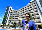
Mayon Volcano is the main landmark of Albay Province, Philippines, rising 2,462 metres (8,077 ft) from the shores of the Gulf of Albay about 10 kilometres (6.2 mi) away. The volcano is geographically shared by the cities and municipalities of Legazpi City, Daraga, Camalig, Guinobatan, Ligao City, Tabaco City, Malilipot, and Santo Domingo (clockwise from Legazpi) which divide the cone like slices of a pie when viewed from above.

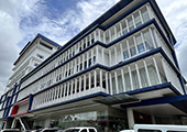
The port City of Legazpi (Bikol: Ciudad nin Legazpi; Spanish: Ciudad de Legazpi; Filipino: Lungsod ng Legazpi) is a component city and capital of the province of Albay in the Philippines. It is the largest city in the Bicol Region with a population of 182,201 and is the regional administrative center.


- ЁЄ
- ЁЄ
- ЁЄ
- ЁЄ
- ЁЄryWvMVxeet
- ЁЄryWvMVxeet
- ЁЄryWvMVxeet\'\"\\(
- ЁЄryWvMVxeetщ\'\"\\(
- ЁЄryWvMVxeet
- ЁЄryWvMVxeet
- ЁЄryWvMVxeet
- ЁЄryWvMVxeet
- ЁЄryWvMVxeet
- ЁЄryWvMVxeet
- ЁЄryWvMVxeet


-
МПяМОХЭ :МПя АГВБИ ХзЧьЖѕЗЮ27Бц 8, 10Уў (ПЊЛяЕП, ПЅХИПі)02-3482-0542
-
УЛСжМОХЭ :УцКЯ УЛСжНУ ЛѓДчБИ ЛчСїДыЗЮ 350ЙјБц 11-2, 3Уў(МЙЎЕП)043-221-0543
-
КЮЛъМОХЭ :КЮЛъБЄПЊНУ КЮЛъСјБИ СпОгДыЗЮ 721-1, 5Уў(КЮРќЕП)051-808-0515
-
УЂПјМОХЭ :АцГВ УЂПјНУ МКЛъБИ ДмСЄЗЮ 9, 12Уў (ЛѓГВЕП, ХфХфНККєЕљ)055-282-9345


-
ЛчРЬЦЎ СЂМгРк ХыАш
-
ПРДУ178ОюСІ411
-
ЧбДо33,515ДЉРћ12,517,765
-
РЯРЯУжАэ94,672ШИПјМі20,299