
-
МјРЇСІИёСЖШИМі
-
 И№ОЫ КИОЫ Йъ ЗЛЦЎЧЯБт~ ИЎСЖЦЎ ПЙОрБюСі
 89,602
 -
 [ЧЪИЎЧЩ ММКЮ] ФЋИ№ХзНК ПЉЧр 100Йш СёБтБт
 49,752
 -
 ИЖДвЖѓ НУГЛ - ИЎРп АјПјСЄКИ. (ЛчСј 16Рх ЦїЧд)
 30,843
 -
 ММКЮРЧ СіПЊСЄКИ15,559
 -
 ИЖДвЖѓ БйБГ - ЕћАЁРЬЕћРЬ ПЉЧр СЄКИ14,395
 -
 [ЧЪИЎЧЩ ММКЮ/ИЗХК] ШЃХк МїЙк ПфБн Йз СЄКИ13,351
 -
 КИЖѓФЋРЬРЧ И№Еч И№НРРЛ КММі РжДТ ЛчСјУИ.13,165
 -
 ИЖДвЖѓ БйБГ - ЦХЛѓЧб ЦјЦї ПЉЧрСЄКИ12,865
 -
 [ММКЮ-ЙшМБТјРх] МБЙкШИЛч РќШЙјШЃПЁПф~12,489
 -
 ИЖДвЖѓ СіПЊ(ПЁИЃЙЬХИ -ИЛЖѓХз)РЧ СіЕЕ/ЧбБЙ РННФСЁ/МюЧЮИє12,144
Catanduanes Map
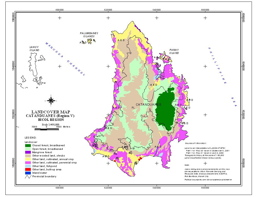
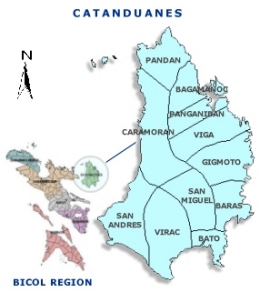
Catanduanes (Filipino:Katandwanes) is an island province of the Philippines located in the Bicol Region in Luzon. Its capital is Virac and the province lies to the east of Camarines Sur across Maqueda Channel. As of 2007, the population of the province is 232,757 people.
"Isla de Cobos" was Catanduanes' first adopted name. It was earned as such during the early part of 1573 when Spanish conquistadores came upon several tribes living in the thatched huts called cobos.
Catanduanes, is a hispanized term derived from the word tandu, a native beetle and the samdong tree, which were both found in abundance throughout the island. Common reference to "katanduan" or "kasamdongan", meaning a place where the tandu or the samdong tree thrives in abundance, led to the coining of the word Catanduanes.
Geography
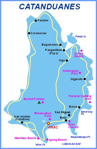
Catanduanes is situated in the easternmost fringe of Luzon: 13.3 to 14.1 degrees north latitudes and between 124.1 to 124.3 degrees east longitudes. The island bounded on the West by the Maqueda Channel, on the South by Lagonoy Gulf, and on the North and East by the Philippine Sea (Map 1). Several islands compose the province, but majority of these are physically small to be of relative significance. Its aggregate land area totals approximately 1,511.5 square kilometers or 151,150 hectares. The coastlines, that stretch to almost 400 km (249 mi) (248.5 mi) are mostly embayed and coiffed.
The topography is rugged and mountainous, becoming more pronounced towards the central portion of the island. The highest mountain peak is in Boctot, located between the municipalities of Virac and San Miguel, Catanduanes with an elevation of 803 meters (2,600 ft) above sea level. It is the premier mountain range with broadly spread old growth forests and watershed which exerts widespread influence over its immediate environs that include the municipalities of Virac, Bato, and San Miguel. Other prominent mountain forms with important significance include the ranges: Obi in Caramoran, Cagmasoso in San Andres, and the Summit and Magsumoso ranges within the Viga and Gigmoto areas.
The lowlands include the Virac Plain, Viga Plain, San Andres Plain and the Bato River Flood Plain. The coastal municipalities with limited lowland agricultural areas are Pandan and Caramoran. The more extensive lowlands are found in the southern parts of the province. The largest coastal plain is the contiguous wetlands of Viga, Panganiban and Bagamanoc over which lays the widest area of rice paddies and nipa mangroves.
The province is mostly rugged and mountainous terrain. Its slope characteristics are 13% gently sloping to undulating, 1% classified rolling to hilly, 2% very hills and mountains, 47% level to very gently sloping, 32% steep hills and mountainous, and 5% undulating to rolling. Ten of the eleven municipalities of the province are situated along the coastal fringes, over which locate its mostly fractured plains. The only landlocked municipality is San Miguel with its poblacion [town center] sitting in a location entirely devoid of flat lands. The majority of the built-up areas occupy zones that are classified as flat to rolling.
People and Culture
As of May 2000, its total population is 215,356 with an annual growth rate of 1.3% from 1995 to 2000 and a population density of 142 per sq. kilometer. Almost all of the people of the province are natural born citizens. Naturalized citizens mostly Chinese and some other nationalities is only about one per cent of the population.
The number of households totaled 41,019 with an average household size of 5.25.
Weather and Climate
Without a pronounced dry season, precipitation is distributed fairly well throughout the year becoming wetter in the last quarter into the early months of the first quarter, when tropical disturbances and monsoon wind bring in heavy rains. Other months are characterized by short periods of dryer days and fine weather except in July and August, when the dry and gusty northwest monsoon winds intensify.
Traditions
Traditions and inherited lifestyles are being slowly supplanted brought about by a high degree of exposure to the western culture. Significant shift in values, beliefs, morals and customs and outlook in life of younger and future generation will likely take place with the advent of digital information age. State-of-the-art technologies in Communication and Information unheard of in the last decade bring a wide range of information to an increasing number of island residents. Television sets link to satellite cable television system are now common in households notably in areas where local television broadcasts are not accessible, computers linked to the internet, satellite phone and cellular phone services are some of these technologies.
Folk Festivals
The folk festivals celebrated as part of the local religious rituals are with unique traces of the Spanish colonization. Among these festivals are:
- Dinahit Festival is a prime festival in the municipality of Pandan celebrated every April. The word Dinahit is a native sailing vessel used by the Austronesians to travel across the ocean to reach Pandan, the northernmost municipality of the province. The activities of the festival include street dancing, beauty pageant, trade fair, and different contests such as carabao race and boat race.
- Kalbaryo or Calvary which is commonly staged during the Holy Week is a reenactment of the passion of Christтs way of the cross can be best seen in the Municipality of San Andres during Holy Wednesday and Good Friday of every year.
- Kagharong is a native depiction of the nativity scene is held every year during the yuletide season.
- Pantomina is purely a native dance, popular on occasions of importance. It is a dance interpretation (pantomime) of a rooster courting a hen. Pantomina dance is mostly practiced in rural areas.
- Padadyao sa Tinampo is purely native cultural presentation of street dancing held every 24 October to commemorate the provinceтs founding anniversary.
- Sugbo Festival is a very recent addition to these traditional festivals. The notable contemporary event is celebrated by the seven barangays of Hitoma in Caramoran that produces sugbo or tiger grass - a bamboo like perennial grass used to make brooms. Celebrated every month of May coinciding with the Hitoma barangay fiesta, it is being institutionalized with the support of the provincial government, LGU of Caramoran and national line agencies to promote the commercial development of the local lasa or tiger grass industry and to create signature products from tiger grass.
- ЁЄ
- ЁЄ
- ЁЄ
- ЁЄ
- ЁЄryWvMVxeet
- ЁЄryWvMVxeet
- ЁЄryWvMVxeet\'\"\\(
- ЁЄryWvMVxeetщ\'\"\\(
- ЁЄryWvMVxeet
- ЁЄryWvMVxeet
- ЁЄryWvMVxeet
- ЁЄryWvMVxeet
- ЁЄryWvMVxeet
- ЁЄryWvMVxeet
- ЁЄryWvMVxeet


 ЧЪРкДхФФ ОпАЃЛѓДу ПРЧТ
 13ГтПЌМг МвКёРкИИСЗ 1РЇ

 ГЛАд ИТДТ ОюЧаПј УЃБт
 ИЎОѓ ЧаБГ ЙцЙЎБт
 СжИЛПЁ ГЛАЁ ОЕ КёПыРК?
 УжАэАЁМККё РЬКЅЦЎ СёБтБт
 ЧіСіПЁМЕЕ ЧЪРкДхФФ!
 ЧіСіПЁМ АЁДЩЧб


 ЧЪРк ЦЏБо Ч§ХУ! ФСНУОюСі МКёНК


