
-
МјРЇСІИёСЖШИМі
-
 И№ОЫ КИОЫ Йъ ЗЛЦЎЧЯБт~ ИЎСЖЦЎ ПЙОрБюСі
 89,650
 -
 [ЧЪИЎЧЩ ММКЮ] ФЋИ№ХзНК ПЉЧр 100Йш СёБтБт
 49,893
 -
 ИЖДвЖѓ НУГЛ - ИЎРп АјПјСЄКИ. (ЛчСј 16Рх ЦїЧд)
 30,864
 -
 ММКЮРЧ СіПЊСЄКИ15,568
 -
 ИЖДвЖѓ БйБГ - ЕћАЁРЬЕћРЬ ПЉЧр СЄКИ14,423
 -
 [ЧЪИЎЧЩ ММКЮ/ИЗХК] ШЃХк МїЙк ПфБн Йз СЄКИ13,368
 -
 КИЖѓФЋРЬРЧ И№Еч И№НРРЛ КММі РжДТ ЛчСјУИ.13,186
 -
 ИЖДвЖѓ БйБГ - ЦХЛѓЧб ЦјЦї ПЉЧрСЄКИ12,886
 -
 [ММКЮ-ЙшМБТјРх] МБЙкШИЛч РќШЙјШЃПЁПф~12,506
 -
 ИЖДвЖѓ СіПЊ(ПЁИЃЙЬХИ -ИЛЖѓХз)РЧ СіЕЕ/ЧбБЙ РННФСЁ/МюЧЮИє12,163
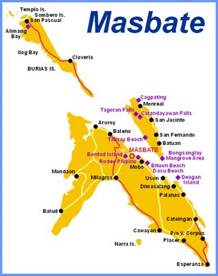
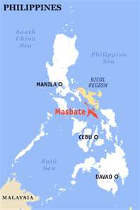
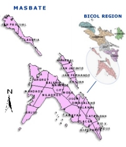
The province of Masbate
The Province of Masbate lies at the center of the Philippine Archipelago. It is composed of a wedge-shaped mainland (Masbate), two major islands (Ticao and Burias) and 14 small islands. It is bounded on the north by the Bicol Mainland, on the south by the Visayan Sea, on the west by Sibuyan Sea and on the east by the Burias Pass, Ticao Pass and Samar Sea.
The province covers a total land area of 4,047.7 square kilometers. It is politically subdivided into three congressional districts, 20 municipalities, one city and 550 barangays. Masbate had a population of 768,939 as of the 2007 census, growing at an average rate of 1.15 percent from 2000 to 2007. The province had an average population density of 190.0 persons per square kilometer.
Masbate is the biggest cattle raising province in the region. Its main economic activity is agriculture with copra, rice, corn and tobacco as its main products. Fishing is also a major industry in the province. Until lately, the province is the site of the biggest gold mining operation in the region. Other minerals found in the island province are manganese and limestone.
Due to its geographic location, Masbate is a melting pot of dialects and cultures. Residents in the capital town of Masbate speak the native Masbate�o with a mixture of the Bicol dialect; natives of Cataingan, Palanas, and Dimasalang along its east coast use Samar-Visayan; residents from Pio V. Corpus, Cataingan and Placer in the south speak Bohol and Cebu Visayan; along the western coast of Mandaon and Balud, people converse in Ilongo and Capice�o; natives of the Burias island talk in variants of the Bicol dialect and Visayan due mainly to the droves of migrants to the island during the sixties.
- ЁЄ

- ЁЄ
- ЁЄ
- ЁЄ
- ЁЄ
- ЁЄryWvMVxeet
- ЁЄryWvMVxeet
- ЁЄryWvMVxeet\'\"\\(
- ЁЄryWvMVxeetщ\'\"\\(
- ЁЄryWvMVxeet
- ЁЄryWvMVxeet
- ЁЄryWvMVxeet
- ЁЄryWvMVxeet
- ЁЄryWvMVxeet
- ЁЄryWvMVxeet


 ЧЪРкДхФФ ОпАЃЛѓДу ПРЧТ
 13ГтПЌМг МвКёРкИИСЗ 1РЇ

 ГЛАд ИТДТ ОюЧаПј УЃБт
 ИЎОѓ ЧаБГ ЙцЙЎБт
 СжИЛПЁ ГЛАЁ ОЕ КёПыРК?
 УжАэАЁМККё РЬКЅЦЎ СёБтБт
 ЧіСіПЁМЕЕ ЧЪРкДхФФ!
 ЧіСіПЁМ АЁДЩЧб


 ЧЪРк ЦЏБо Ч§ХУ! ФСНУОюСі МКёНК


