


![]()


ЧЪРкДКНК

- ЁЄ ЧЪИЎЧЩ HOT
- ЁЄ ЧбБЙ HOT
- ЁЄ ЧСЗЮИ№МЧ HOT
- ЁЄ ШИЛчМвАГ
 13ГтПЌМг МвКёРкИИСЗ 1РЇ
ЧЪИЎЧЩПЌМіСЄКИ
ЧЪИЎЧЩЧаПјСЄКИ
ЧЪИЎЧЩПЌМіКёПы
ЧЪИЎЧЩУтБЙСиКё
ЧЪИЎЧЩСЄКИ
ЧиПмПЌАшПЌМі
СжДЯОюЧЪИЎЧЩ ПЌМі
ЧЪРкДТУрСІДй
ЧЪИЎЧЩ ЧіСі ЛчЙЋНЧ
ЧЪИЎЧЩПЌМіЧСИЎЙЬОі МКёНК
ЧЪИЎЧЩ ОюЧаПЌМіРЬКЅЦЎ
ЧЪИЎЧЩАЁСЗПЌМі
ЧЪИЎЧЩСЖБтРЏЧа
ЧЪРкДхФФЧиПмЛчЙЋНЧ
 ЧЪРкДхФФ ОпАЃЛѓДу ПРЧТ
 ГЛАд ИТДТ ОюЧаПј УЃБт
 ИЎОѓ ЧаБГ ЙцЙЎБт
 СжИЛПЁ ГЛАЁ ОЕ КёПыРК?
 УжАэАЁМККё РЬКЅЦЎ СёБтБт
 ЧіСіПЁМЕЕ ЧЪРкДхФФ!
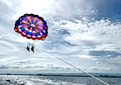 ЧіСіПЁМ АЁДЩЧб


 ЧЪРк ЦЏБо Ч§ХУ! ФСНУОюСі МКёНК


-
МјРЇСІИёСЖШИМі
-
 И№ОЫ КИОЫ Йъ ЗЛЦЎЧЯБт~ ИЎСЖЦЎ ПЙОрБюСі
 89,617
 -
 [ЧЪИЎЧЩ ММКЮ] ФЋИ№ХзНК ПЉЧр 100Йш СёБтБт 49,809
 -
 ИЖДвЖѓ НУГЛ - ИЎРп АјПјСЄКИ. (ЛчСј 16Рх ЦїЧд) 30,851
 -
 ММКЮРЧ СіПЊСЄКИ15,564
 -
 ИЖДвЖѓ БйБГ - ЕћАЁРЬЕћРЬ ПЉЧр СЄКИ14,408
 -
 [ЧЪИЎЧЩ ММКЮ/ИЗХК] ШЃХк МїЙк ПфБн Йз СЄКИ13,363
 -
 КИЖѓФЋРЬРЧ И№Еч И№НРРЛ КММі РжДТ ЛчСјУИ.13,173
 -
 ИЖДвЖѓ БйБГ - ЦХЛѓЧб ЦјЦї ПЉЧрСЄКИ12,873
 -
 [ММКЮ-ЙшМБТјРх] МБЙкШИЛч РќШЙјШЃПЁПф~12,500
 -
 ИЖДвЖѓ СіПЊ(ПЁИЃЙЬХИ -ИЛЖѓХз)РЧ СіЕЕ/ЧбБЙ РННФСЁ/МюЧЮИє12,151


- РЬИЇ : jilo
- РлМКРЯ : 2012-01-25
- СЖШИМі : 3328
- УпУЕМі : 3
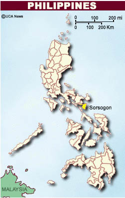
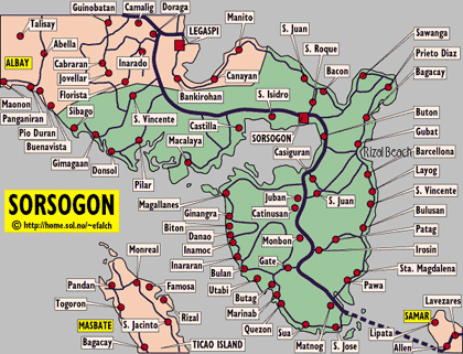
Sorsogon is a province of the Philippines located in the Bicol Region; it is the southernmost province in Luzon
and is subdivided into fourteen municipalities (towns) and one city. Its capital is Sorsogon City (formerly the
towns of Sorsogon and Bacon) and borders the province of Albay to the north. Sorsogon is at the tip of the
Bicol Peninsula and faces the island of Samar to the southeast across the San Bernardino Strait and
Ticao Island to the southwest.
History
Ferdinand Magellanтs death in 1521, in the hands of Lapu-lapu did not stop the Spanish colonization of the
Philippine Islands. In 1570 two Augustinian friars, Fr. Alonzon Jimenez and Fr. Juan Orta, accompanied by a
certain Capt. Enrique de Guzman, reached Hibalong, a small fishing village near the mouth of Ginangra River
in Magallanes and planted the cross and erected the first chapel in Luzon. It was from this village that Ibalong,
referring to the whole region came to be. Moving inland with a northwesterly direction they passed by the territory now known as Pilar, before they reached Camalig, Albay. The establishment of the Abucay-Catamlangan
Mission later was ample proof of this route.
Sorsogon was once a part of Albay, which also included the province of Masbate. The early towns established
here were: Gibalon in 1570 (now sitio of Magallanes); Casiguran -1600; Bulusan – 1631; Pilar – 1635; Donsol –
1668; Bacon – 1764; Juban and Matnog - 1800; Bulan - 1801; Castilla – 1827; Magallanes – 1860; Sorsogon – 1866 and Irosin – 1880.
The province was eventually separated from Albay on October 17, 1894 and adopted the name Sorsogon.
The town of Sorsogon was also selected as its capital.
On 1935 Philippine Constitutional Convention, Sorsogon had its own delegates. They were Adolfo Grafilo, Francisco Arellano, Jose S. Reyes and Mario Guarino.
Geography
Sorsogon, at the southeastern part of the Bicol Peninsula, is bounded on the north by the province of Albay,
on the east by the Philippine Sea, on the south by the San Bernardino Strait, and on the west and northwest by
the Ticao and Burias Passes. It has a total land area of 2,119 km2.
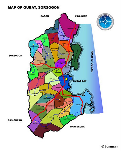
It is characterized by an irregular topography, and, except for landlocked Irosin, all the towns lie along the coast. They are all connected by concrete and asphalt roads. Mountains sprawl over the northeast, southeast and west portions. Mt. Bulusan, the tallest peak, rises 1,560 meters above sea level.
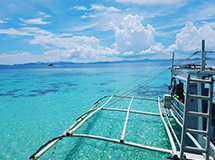
Except for its overland link with the province of Albay to the north, it is completely surrounded by water. Sorsogon is the gateway of Luzon to the Visayas and Mindanao through its Roll-on/Roll-off ferry terminal facilities
located in the municipalities of Matnog, Pilar and Bulan.
Economy
The province's economic activity is highly concentrated in its capital city, Sorsogon City, and the towns of
Bulan, Irosin, Gubat, and Matnog as well. Sorsogon Province is classified as 2nd class with an average annual
income of ₱339.4M (C.Ys. 2000-2003). This is about ₱11M short for the province to attain 1st class
reclassification which requires at least ₱350M average annual income.
The Province of Sorsogon indeed had a great contribution on the 97-percent growth in investments for the first quarter of 2008 and increasing tourism arrivals that buoyed the Bicol Region economy, despite the damage brought about by incessant rains and a rice shortage. This is according to the Quarterly Regional Economic Situationer (QRES) released by the National Economic and Development Authority (NEDA) Regional Office in Bicol (NRO 5).
Among the provinces, Sorsogon posted the highest growth (293% respectively) in investments from the previous year. Next to Sorsogon is Catanduanes that posted a growth of 280%. Albay contributed 39 percent to the region's investments and posted a growth of 221% from the preceding quarter.
тFor the third time, Bicol Region hosted the kick-off of Asia's premier extreme sailing event, the Philippine
Hobie Challenge last February 16 at Gubat, Sorsogon. This 260-mile journey from Gubat-Sambuyan-
Bacsal-Marambut-Suluan[4] to Siargao enticed both local and foreign water sports enthusiasts. It opened
the opportunity for the municipality of Gubat to showcase the town's best,т the QRES stated.


- ЁЄ
- ЁЄ
- ЁЄ
- ЁЄ
- ЁЄryWvMVxeet
- ЁЄryWvMVxeet
- ЁЄryWvMVxeet\'\"\\(
- ЁЄryWvMVxeetщ\'\"\\(
- ЁЄryWvMVxeet
- ЁЄryWvMVxeet
- ЁЄryWvMVxeet
- ЁЄryWvMVxeet
- ЁЄryWvMVxeet
- ЁЄryWvMVxeet
- ЁЄryWvMVxeet


-
МПяМОХЭ :МПя АГВБИ ХзЧьЖѕЗЮ27Бц 8, 10Уў (ПЊЛяЕП, ПЅХИПі)02-3482-0542
-
УЛСжМОХЭ :УцКЯ УЛСжНУ ЛѓДчБИ ЛчСїДыЗЮ 350ЙјБц 11-2, 3Уў(МЙЎЕП)043-221-0543
-
КЮЛъМОХЭ :КЮЛъБЄПЊНУ КЮЛъСјБИ СпОгДыЗЮ 721-1, 5Уў(КЮРќЕП)051-808-0515
-
УЂПјМОХЭ :АцГВ УЂПјНУ МКЛъБИ ДмСЄЗЮ 9, 12Уў (ЛѓГВЕП, ХфХфНККєЕљ)055-282-9345


-
ЛчРЬЦЎ СЂМгРк ХыАш
-
ПРДУ117ОюСІ411
-
ЧбДо33,515ДЉРћ12,517,704
-
РЯРЯУжАэ94,672ШИПјМі20,299