
-
МјРЇСІИёСЖШИМі
-
 И№ОЫ КИОЫ Йъ ЗЛЦЎЧЯБт~ ИЎСЖЦЎ ПЙОрБюСі
 89,460
 -
 [ЧЪИЎЧЩ ММКЮ] ФЋИ№ХзНК ПЉЧр 100Йш СёБтБт
 48,913
 -
 ИЖДвЖѓ НУГЛ - ИЎРп АјПјСЄКИ. (ЛчСј 16Рх ЦїЧд)
 30,790
 -
 ММКЮРЧ СіПЊСЄКИ15,531
 -
 ИЖДвЖѓ БйБГ - ЕћАЁРЬЕћРЬ ПЉЧр СЄКИ14,341
 -
 [ЧЪИЎЧЩ ММКЮ/ИЗХК] ШЃХк МїЙк ПфБн Йз СЄКИ13,319
 -
 КИЖѓФЋРЬРЧ И№Еч И№НРРЛ КММі РжДТ ЛчСјУИ.13,132
 -
 ИЖДвЖѓ БйБГ - ЦХЛѓЧб ЦјЦї ПЉЧрСЄКИ12,832
 -
 [ММКЮ-ЙшМБТјРх] МБЙкШИЛч РќШЙјШЃПЁПф~12,447
 -
 ИЖДвЖѓ СіПЊ(ПЁИЃЙЬХИ -ИЛЖѓХз)РЧ СіЕЕ/ЧбБЙ РННФСЁ/МюЧЮИє12,114
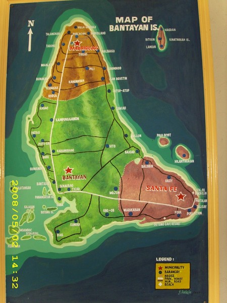
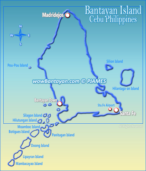
Bantayan Map
Bantayan is a 2nd class municipality on Bantayan Island in the province of Cebu, Philippines.
It is the island's most populous town, with a population of 71,655 people according to the 2007 census. It is
bordered to the north by Madridejos and to the southeast by Santa Fe.Bantayan Islands is geographically in
the center of the Philippines. It is located at the northwestern side of Cebu and northeastern of Negros
Occidental. It is a town of Cebu and is about 80 miles from Cebu City. The main Bantayan Island is about
7 miles wide by 10 miles long. About 20 of its islets stretch for another 5 miles long with some being accessible by foot from the main island at low tide. Mostly all the ships or ferryboats coming from Mindanao or south of
Cebu have to pass by Bantayan Islands on its way to Manila. The Bantayan dialect is a mixture of native
Cebuano, Ilongo (Negros), Waray (Samar), Masbateno, and Boholano, but it has words it can call its own
such as тkakyop, sara, kag buwasт (yesterday, today, and tomorrow).
Bantayan Islands is considered as Cebuтs fishing ground where shiploads and boatloads of fish are transported daily to Cebu City and Negros. Tons of guinamos (salted fish) and buwad (dried fish) are delivered to Cebu City and Cadiz, Negros for further distribution to as far as Mindanao and Manila. Equally important is the thriving
poultry industry with hundreds of thousands of chicken eggs produced daily.
- ЁЄ
- ЁЄ
- ЁЄ
- ЁЄryWvMVxeet
- ЁЄryWvMVxeet
- ЁЄryWvMVxeet\'\"\\(
- ЁЄryWvMVxeetщ\'\"\\(
- ЁЄryWvMVxeet
- ЁЄryWvMVxeet
- ЁЄryWvMVxeet
- ЁЄryWvMVxeet
- ЁЄryWvMVxeet
- ЁЄryWvMVxeet
- ЁЄryWvMVxeet
- ЁЄryWvMVxeet


 ЧЪРкДхФФ ОпАЃЛѓДу ПРЧТ
 12ГтПЌМг МвКёРкИИСЗ 1РЇ
 ГЛАд ИТДТ ОюЧаПј УЃБт
 ИЎОѓ ЧаБГ ЙцЙЎБт
 СжИЛПЁ ГЛАЁ ОЕ КёПыРК?
 УжАэАЁМККё РЬКЅЦЎ СёБтБт
 ЧіСіПЁМЕЕ ЧЪРкДхФФ!
 ЧіСіПЁМ АЁДЩЧб


 ЧЪРк ЦЏБо Ч§ХУ! ФСНУОюСі МКёНК


