
-
МјРЇСІИёСЖШИМі
-
 И№ОЫ КИОЫ Йъ ЗЛЦЎЧЯБт~ ИЎСЖЦЎ ПЙОрБюСі
 89,619
 -
 [ЧЪИЎЧЩ ММКЮ] ФЋИ№ХзНК ПЉЧр 100Йш СёБтБт
 49,812
 -
 ИЖДвЖѓ НУГЛ - ИЎРп АјПјСЄКИ. (ЛчСј 16Рх ЦїЧд)
 30,851
 -
 ММКЮРЧ СіПЊСЄКИ15,564
 -
 ИЖДвЖѓ БйБГ - ЕћАЁРЬЕћРЬ ПЉЧр СЄКИ14,408
 -
 [ЧЪИЎЧЩ ММКЮ/ИЗХК] ШЃХк МїЙк ПфБн Йз СЄКИ13,363
 -
 КИЖѓФЋРЬРЧ И№Еч И№НРРЛ КММі РжДТ ЛчСјУИ.13,176
 -
 ИЖДвЖѓ БйБГ - ЦХЛѓЧб ЦјЦї ПЉЧрСЄКИ12,873
 -
 [ММКЮ-ЙшМБТјРх] МБЙкШИЛч РќШЙјШЃПЁПф~12,500
 -
 ИЖДвЖѓ СіПЊ(ПЁИЃЙЬХИ -ИЛЖѓХз)РЧ СіЕЕ/ЧбБЙ РННФСЁ/МюЧЮИє12,151
Map of Leyte
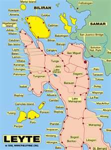
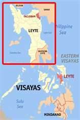
Leyte (also Northern Leyte; Filipino: Hilagang Leyte) is a province of the Philippines located in the Eastern Visayas region. Its capital is Tacloban City and occupies the northern three-quarters of the Leyte Island. Leyte is located west of Samar Island, north of Southern Leyte and south of Biliran. To the west of Leyte across the Camotes Sea is Cebu Province.
The explorer Ruy López de Villalobos, first came to the island in 1543 and named it Las Islas Felipinas.
The island measures about 180 km (110 mi) north-south and about 65 km (40 mi) at its widest point. In the north it nearly joins Samar, separated by the San Juanico Strait, which becomes as narrow as 2 km (1.2 mi) in some places. The island province of Biliran is also to the north of Leyte and is joined to Leyte island by a bridge across the narrow Biliran Strait. To the south Leyte is separated from Mindanao by the Surigao Strait. To the east, Leyte is somewhat "set back" from the Philippine Sea of the Pacific Ocean, Samar to the northeast and Dinagat to the southeast forming the Leyte Gulf. To the west are Cebu and Bohol.
Leyte is mostly heavily forested and mountainous, but the Leyte Valley in the northeast has much agriculture.
Politically, the island is divided into two provinces: (Northern) Leyte and Southern Leyte. Territorially, Southern Leyte Province includes the island of Panaon to its south. Biliran Island, to the north of Leyte Island, was formerly a sub-province of Leyte, and is now a separate province, Biliran Province.
The chief cities of Leyte are Tacloban City, on the eastern shore at the northwest corner of Leyte Gulf, and Ormoc City, on the west coast.
Leyte today is notable for the geothermal electric power plants near Ormoc.
However, Leyte is most famous for its role in the reconquest of the Philippines in World War II. On 20 October 1944, General Douglas MacArthur waded ashore on Leyte, saying "I have returned". However, the Japanese did not give up so easily, as the ensuing Battle of Leyte proved, and convergence of naval forces resulted in the four-day Battle of Leyte Gulf, the largest naval battle in history.
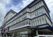
The Leyte Provincial Capitol is the seat of the provincial government where historic viewing of a mural depicting the First Mass of Limasawa in the Orient and the landing of Gen. Douglas MacArthur can be done.
The Leyte Landing Memorial in Red Beach, Palo, marks the spot where American liberation forces landed it also has a lagoon where the life-size statues of Gen. McArthur and his fleet stands.
Lake Danao is a violin-shaped lake hemmed by cloud-capped mountain ranges. It is a hunterтs paradise where wild animals roam the surrounding forests. It is also said to be the home of a giant eel.
Calanggaman Island in Palompon, Leyte is a virgin island with pure white side. It has two long sandbars. The ecological atmosphere of the island had been preserved by the municipality.
The Sto. Nino Shrine and Heritage Museum boasts the painting of the 14 station of the cross done by Filipino artists and a bas-relief of the legend of the first Filipino man and woman (Malakas and Maganda).
The San Juanico Bridge is the longest and the most beautifully designed bridge in the Philippines. It features the picturesque San Juanico Strait with a thousand whirlpools, lovely islets and view.
Leyte Island is the birthplace of the Tinikling dance, which is very popular throughout the Philippines.
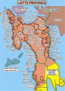
People, language and culture
The people of Leyte are divided into two main groups, primarily by language. In the west and south are the Cebuanos, while in the north and east is the Waray-Waray (Leyte dialect).
There are also some Spanish mestizos and some natives of the province who can understand and speak Spanish due to the province's colonial history.
According to the Year 2000 census, 97% of Leyte's population is Roman Catholics, one of the highest percentage in the Visayas. While the remaining 3% are either adherents of other different Christian sects such as the indigenous Baptists, Evangelicals, Mennonites, and Mormons, Christian.
Battle of Leyte Gulf
During World War II under the Japanese Occupation, the 9th and 92nd Infantry Division of the Philippine Commonwealth Army was reestablished from 1942 to 1946 at the military general headquarters and military camps and garrisoned in Tacloban and Ormoc before the liberation of the Philippines was the military unit organization and started by the Anti-Japanese military operations in the province of Leyte from 1942 to 1945 to helping the local guerrilla groups under by Colonel Ruperto Kangleon and the American liberating forces and fought against the Japanese Imperial forces.The Battle of Leyte Gulf took place in the seas surrounding this island from 23 October to 26 October 1944. It was the largest naval battle in modern history, when at least 212 Allied ships clashed with the remnants of the Imperial Japanese Navy, some 60 ships, including the super battleships Yamato and Musashi.
The First Battle of Leyte occurred on 20 October 1944. A successful Allied invasion of the island was the crucial element to the eventual Filipino and American victory in the Philippines
- ЁЄ
- ЁЄ
- ЁЄ
- ЁЄ
- ЁЄryWvMVxeet
- ЁЄryWvMVxeet
- ЁЄryWvMVxeet\'\"\\(
- ЁЄryWvMVxeetщ\'\"\\(
- ЁЄryWvMVxeet
- ЁЄryWvMVxeet
- ЁЄryWvMVxeet
- ЁЄryWvMVxeet
- ЁЄryWvMVxeet
- ЁЄryWvMVxeet
- ЁЄryWvMVxeet





 ЧЪРкДхФФ ОпАЃЛѓДу ПРЧТ
 13ГтПЌМг МвКёРкИИСЗ 1РЇ

 ГЛАд ИТДТ ОюЧаПј УЃБт
 ИЎОѓ ЧаБГ ЙцЙЎБт
 СжИЛПЁ ГЛАЁ ОЕ КёПыРК?
 УжАэАЁМККё РЬКЅЦЎ СёБтБт
 ЧіСіПЁМЕЕ ЧЪРкДхФФ!
 ЧіСіПЁМ АЁДЩЧб


 ЧЪРк ЦЏБо Ч§ХУ! ФСНУОюСі МКёНК


