-
МјРЇСІИёСЖШИМі
-
 И№ОЫ КИОЫ Йъ ЗЛЦЎЧЯБт~ ИЎСЖЦЎ ПЙОрБюСі
 89,602
 -
 [ЧЪИЎЧЩ ММКЮ] ФЋИ№ХзНК ПЉЧр 100Йш СёБтБт
 49,756
 -
 ИЖДвЖѓ НУГЛ - ИЎРп АјПјСЄКИ. (ЛчСј 16Рх ЦїЧд)
 30,843
 -
 ММКЮРЧ СіПЊСЄКИ15,559
 -
 ИЖДвЖѓ БйБГ - ЕћАЁРЬЕћРЬ ПЉЧр СЄКИ14,395
 -
 [ЧЪИЎЧЩ ММКЮ/ИЗХК] ШЃХк МїЙк ПфБн Йз СЄКИ13,351
 -
 КИЖѓФЋРЬРЧ И№Еч И№НРРЛ КММі РжДТ ЛчСјУИ.13,165
 -
 ИЖДвЖѓ БйБГ - ЦХЛѓЧб ЦјЦї ПЉЧрСЄКИ12,865
 -
 [ММКЮ-ЙшМБТјРх] МБЙкШИЛч РќШЙјШЃПЁПф~12,489
 -
 ИЖДвЖѓ СіПЊ(ПЁИЃЙЬХИ -ИЛЖѓХз)РЧ СіЕЕ/ЧбБЙ РННФСЁ/МюЧЮИє12,144
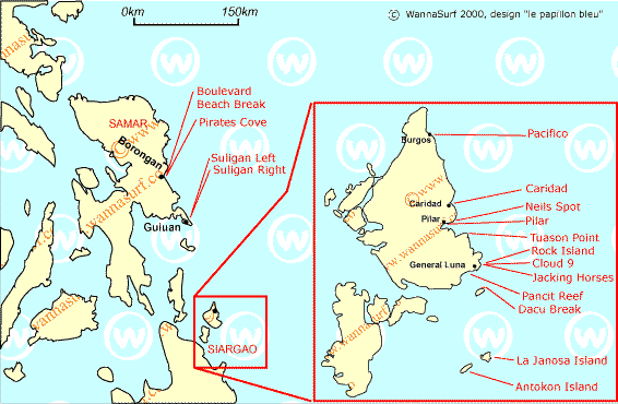
SIARGAO ISLAND
Location : Siargao Island is one of the islands
of the province of Surigao del Norte, 800 km away from Manila.
It is proximate to the Philippine Deep,
which is 10,700 meters below sea level,
considered the deepest part of the trench.
Land Area : 62,796 hectares
Topography :Predominantly rolling to steep.
The highest elevation is 291 meters above sea level
located along the middle of Bucas Grande island.
On the western and southern sides of the island are broad
expanse of mangrove swamps and broad reef flats.
Climate : The island, and the entire province, falls under climate type II characterized by no pronounced dry season but with a very pronounced maximum rainfall period from
November to January. Temperature ranges from a low of 21.1 degree celcius in
October to a high of 35.2 degree celcius in June.
Population : Approximately 100,000 for all nine (9) municipalities
Land Area : 67,726 hectares
Political Subdivision: Siargao Island is composed of 9 municipalities, namely, Burgos,
Dapa, Del Carmen, General Luna, Pilar, San Benito, San Isidro, Santa Monica and
Socorro, with a total of 131 barangays
Language and Dialects: Surigaonon, Cebuano, Boholano, Tagalog and English are the
major languages/dialects spoken in the island.
- ЁЄ
- ЁЄ
- ЁЄ
- ЁЄ
- ЁЄryWvMVxeet
- ЁЄryWvMVxeet
- ЁЄryWvMVxeet\'\"\\(
- ЁЄryWvMVxeetщ\'\"\\(
- ЁЄryWvMVxeet
- ЁЄryWvMVxeet
- ЁЄryWvMVxeet
- ЁЄryWvMVxeet
- ЁЄryWvMVxeet
- ЁЄryWvMVxeet
- ЁЄryWvMVxeet


 ЧЪРкДхФФ ОпАЃЛѓДу ПРЧТ
 13ГтПЌМг МвКёРкИИСЗ 1РЇ

 ГЛАд ИТДТ ОюЧаПј УЃБт
 ИЎОѓ ЧаБГ ЙцЙЎБт
 СжИЛПЁ ГЛАЁ ОЕ КёПыРК?
 УжАэАЁМККё РЬКЅЦЎ СёБтБт
 ЧіСіПЁМЕЕ ЧЪРкДхФФ!
 ЧіСіПЁМ АЁДЩЧб


 ЧЪРк ЦЏБо Ч§ХУ! ФСНУОюСі МКёНК


