
-
МјРЇСІИёСЖШИМі
-
 И№ОЫ КИОЫ Йъ ЗЛЦЎЧЯБт~ ИЎСЖЦЎ ПЙОрБюСі
 88,728
 -
 [ЧЪИЎЧЩ ММКЮ] ФЋИ№ХзНК ПЉЧр 100Йш СёБтБт
 43,840
 -
 ИЖДвЖѓ НУГЛ - ИЎРп АјПјСЄКИ. (ЛчСј 16Рх ЦїЧд)
 30,368
 -
 ММКЮРЧ СіПЊСЄКИ15,299
 -
 ИЖДвЖѓ БйБГ - ЕћАЁРЬЕћРЬ ПЉЧр СЄКИ13,945
 -
 [ЧЪИЎЧЩ ММКЮ/ИЗХК] ШЃХк МїЙк ПфБн Йз СЄКИ12,965
 -
 КИЖѓФЋРЬРЧ И№Еч И№НРРЛ КММі РжДТ ЛчСјУИ.12,803
 -
 ИЖДвЖѓ БйБГ - ЦХЛѓЧб ЦјЦї ПЉЧрСЄКИ12,482
 -
 [ММКЮ-ЙшМБТјРх] МБЙкШИЛч РќШЙјШЃПЁПф~12,024
 -
 ИЖДвЖѓ СіПЊ(ПЁИЃЙЬХИ -ИЛЖѓХз)РЧ СіЕЕ/ЧбБЙ РННФСЁ/МюЧЮИє11,770
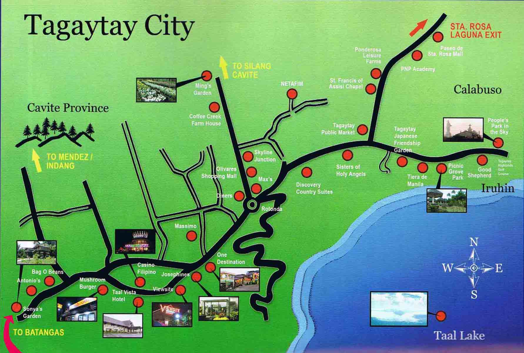
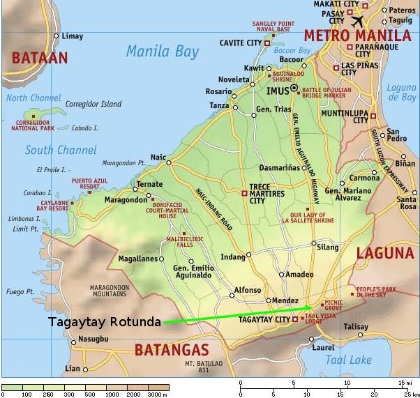
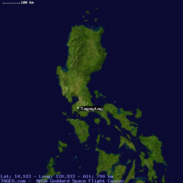
The City of Tagaytay (Filipino: Lungsod ng Tagaytay) is a component city in the province of Cavite, in the Philippines. It is one of the country's most popular tourist destinations because of outstanding scenery and cooler climate provided by its high altitude. Tagaytay overlooks Taal Lake in Batangas and provides one of the iconic views of the Philippines, the view of Taal Volcano Island in the middle of the lake, viewable from several vantage points in the city.
Tagaytay is relatively close to the capital city of Manila, only 55 km (34 mi) away via Aguinaldo Highway, providing an easy escape for the locals from the heat of the big city.
Climate
Temperature and precipitation
Tagaytay City's subtropical-like climate is characterized by relatively low temperature, low humidity and abundant rainfall. The City is endowed with a cool and invigorating climate with an average temperature of 22.7 ТАC (72.9 ТАF). With its high elevation, the city could be misty at times and is relatively cooler during the months of December, January and February. Like most areas in the province of Cavite, the city has two pronounced seasons: dry from November to April and wet during the rest of the year. The climate has made the city ideal for sports, picnics, conferences, honeymoons, country homes, and spiritual retreats.
Humidity
Tagaytay has an average humidity of 78% which makes the city cooler than Metro Manila where relative humidity exceeds 81%. Northeasterly winds prevail in the City from October to April. Winds come from southwest from May to September. The cool Tagaytay breeze has made the city ideal for casual and competitive kite flying.
History
Timeline
- 1749. Taal Volcano destroyed the entire Volcano Island and the towns of Taal, old Sala and part of old Tanauan.
- 1754. The eruption of Taal Volcano destroyed towns of Sala, Lipa, Tanauan and Talisay.
- 1911. Another eruption devastated Volcano Island killing 1,334 people with ashes reaching Manila.
- 1937. Construction ensues on Tagaytay ridge. Taal Vista Lodge is built, to be run by the Manila Hotel Corporation. Cavite prisoners construct the long highway stretching from Silang up to the ridge. This is the continuation of the Aguinaldo Highway, named after the First President of the Republic of the Philippines, Emilio Aguinaldo.
- 1938. Tagaytay became a chartered city with the passing and signing of Commonwealth Act no. 338 by PresidentManuel L. Quezon on January 21, 1938, as authored by Rep. Justiniano Montano of Cavite.[4]
- 1965. The Volcano affected the entire Volcano Island; ashfall covered an area of 60 square kilometres (23 sq mi) and killed 200 people.
- 1979. Former First Lady Imelda Marcos brought a major change to the landscape of the city. Mount Sungay was leveled to about half of its former prominence to accommodate the Palace in the Sky, a mansion originally intended as a guesthouse for former California Gov. Ronald Reagan - who never arrived. The half-finished Palace in the Sky became the People's Park in the Sky after the People Power Revolution, which toppled the government of PresidentFerdinand Marcos.
- 1992. Mayor Benjamin Erni improved the roads that lead to the smaller barangays and erected the fruit arch on the city boundary to welcome visitors and investors.
Tagaytay City has a total land area of 66.1 km2 (26 sq mi) which represents about 4.37% of the total area of the Province of Cavite. It lies within 120ТА 56' longitude and 14ТА 6' latitude and overlooks Manila Bay to the North, Taal Volcano and Lake to the south and Laguna de Bay to the east.
- ЁЄryWvMVxeet
- ЁЄryWvMVxeet
- ЁЄryWvMVxeet\'\"\\(
- ЁЄryWvMVxeetщ\'\"\\(
- ЁЄryWvMVxeet
- ЁЄryWvMVxeet
- ЁЄryWvMVxeet
- ЁЄryWvMVxeet
- ЁЄryWvMVxeet
- ЁЄryWvMVxeet
- ЁЄryWvMVxeet
- ЁЄryWvMVxeet
- ЁЄryWvMVxeet
- ЁЄryWvMVxeet
- ЁЄryWvMVxeet


 ЧЪРкДхФФ ОпАЃЛѓДу ПРЧТ
 11ГтПЌМг МвКёРкИИСЗ 1РЇ
 ГЛАд ИТДТ ОюЧаПј УЃБт
 ИЎОѓ ЧаБГ ЙцЙЎБт
 СжИЛПЁ ГЛАЁ ОЕ КёПыРК?
 УжАэАЁМККё РЬКЅЦЎ СёБтБт
 ЧіСіПЁМЕЕ ЧЪРкДхФФ!
 ЧіСіПЁМ АЁДЩЧб


 ЧЪРк ЦЏБо Ч§ХУ! ФСНУОюСі МКёНК


 АЁСЗПЌМіЗЮ ДйЧдАд ОзЦМКёЦМ


